Natural Reserves in Palestine
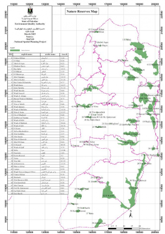
Israeli occupation has declared 48 natural reserves in the West Bank. The total area of the Israeli designated nature reserves is 69,939hectares; forming 12.35% in the year 2005 (Spatial layer at ARIJ GIS department). However the National Spatial Plan prepared by the MoLG indicates that the total area of natural reserves in the West Bank 51,157hectares forming 9% (Isaac et al., 2011). They are located mainly in the eastern slopes and Jordan River area. The Palestinians prevented by Israeli occupation from access and work freely in them, which clarifies that the Israelis policy of nature protection has political aims rather than those of protecting biodiversity. A portion of these reserves have been converted to Israeli colonial settlements and military bases and a large part were included within the Wall of Annexation and Expansion. Map 9 presents the distribution of Nature reserves and forest in West Bank and its overlapping with biodiversity hotspots. It’s noted that most Nature reserves and forest are away from the areas of biodiversity richness, this can explain the above mentioned conflict.
The largest nature reserve is on the riparian areas of the Dead Sea in the Bethlehem governorate, and accounts for more than a fifth of the protected area alone (ARIJ 2005). Most STATE OF PALESTINE FIFTH NATIONAL REPORT (CBD) 2015 of the existing nature reserves in the West Bank belong to the Area C, which means they are fully controlled by the Israeli civil administration (Görlach et al. 2011). Only 13 reserves (or 11.3% of the total reserve area) are within the Area B and are therefore in principle under Palestinian control, unless Israel restricts Palestinian access to Area B. This means that the Palestinian management agency, currently the Ministry of Agriculture, cannot access most of the protected areas on the West Bank for management purposes – although enforcement activities in some reserves may be possible.

