Wadi 'Ein ez Zarqa el 'Elwi
Profile on Protected Planet Website
The reserve constitutes one of the relatively large reserves in the West Bank, and its environment, whether rich in vegetation or the area close to Deir Ballut with light vegetation cover, constitutes an area rich in biodiversity, but the borders have been modified from the side of Kafr al-Dik and Deir Ghasana in light of the urban expansion towards that area and agricultural lands in addition to The problem of waste in that area and the limited structural plans of the villages of Kafr al-Dik, Deir Ghassaneh, and Broqin, the borders have been modified to allow urban expansion towards that area. The borders on the Deir Ballut side were also modified to allow urban expansion from that side due to the lack of important biodiversity in it and the prevailing cover is agricultural lands with the expansion of the borders from the southwestern side to include some areas that need further study from Al Leban Al Gharbeya.
There is a detailed survey and management plan for the area (PMNH 2018):
https://www.palestinenature.org/conservation/WadiZarqaTechnical.pdf
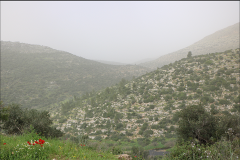
Wadi Ein ez Zarqa el Elwi protected area is located within the borders of the governorates of Ramallah and Al Bireh, Salfeit and covers an area of 13.22 km2
The reserve constitutes one of the relatively large reserves in the West Bank, and its environment, whether rich in vegetation or the area close to Deir Ballut with light vegetation cover, constitutes an area rich in biodiversity, but the borders have been modified from the side of Kafr al-Dik and Deir Ghasana in light of the urban expansion towards that area and agricultural lands in addition to The problem of waste in that area and the limited structural plans of the villages of Kafr al-Dik, Deir Ghassaneh, and Broqin, the borders have been modified to allow urban expansion towards that area. The borders on the Deir Ballut side were also modified to allow urban expansion from that side due to the lack of important biodiversity in it and the prevailing cover is agricultural lands with the expansion of the borders from the southwestern side to include some areas that need further study from Al Leban Al Gharbeya.
There is a detailed survey and management plan for the area (PMNH 2018):
https://www.palestinenature.org/conservation/WadiZarqaTechnical.pdf